Geomorphology
Geoheritage in the Icelandic Landscape
In 2019, the Government of Iceland ratified the European Landscape Convention. The aim of the Convention is to promote the protection, management, and planning of landscapes and to establish European cooperation in landscape matters.
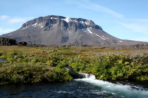
Iceland’s landscape is special, and even unique on a global scale, due to the diversity of its rare landform types. Geoheritage and geological processes (geomorphology) have played a major role in shaping the landscape we see in Iceland today, including glacially-formed landscapes and volcanic terrain. It is important to understand the processes that define different types of landscapes and how they influence the landscape’s conservation value. One example is Iceland’s location on the rift zone of the Mid-Atlantic Ridge, which is clearly reflected in the active volcanic belts of the country. The rift zone is visible in features such as volcanic fissures (tuff ridges and crater rows), which align in a consistent southwest–northeast direction, along with rift fractures, faults, and grabens. Similar landscapes exist on the ocean floor in tectonically active areas, but they are globally unique on land.
What characterizes the Icelandic landscape?
Icelandic landscape research has identified certain distinctive features, particularly in areas of volcanic activity, tuff ridges, and high-temperature geothermal fields. Glaciers and hydrological features are key components of the landscape, including outlet glaciers, glacial lagoons, highland lakes, glacial rivers, waterfalls, and springs. The country’s location in the North Atlantic also plays a significant role in shaping environmental conditions such as climate and the composition of its ecosystems, including vegetation.
In the highlands, unique vegetation oases form where water is available, often near glaciers where glacial sediments and meltwater are nutrient-rich. Permafrost and frost-patterned ground are also examples of geoheritage features that develop under specific climate conditions and enjoy international protection due to their rarity. The Icelandic highlands are notable for their sparse vegetation, wide-open vistas, and dramatic landscapes. Wilderness areas in Iceland, protected under the Nature Conservation Act (No. 60/2013), are defined as: “Uninhabited areas generally at least 25 km² in size, where solitude and nature can be experienced without disturbance from structures or motorized traffic [...]”. Such areas have become rare in Europe, which in turn increases the conservation value of those that remain. Other elements that contribute to the uniqueness of Iceland’s landscape include biological and cultural features, such as moss-covered lava fields and patchy vegetation cover shaped by human history.
Reference:
Þóra Ellen Þórhallsdóttir, Þorvarður Árnason, Hlynur Bárðarson og Karen Pálsdóttir, 2010. Íslenskt landslag. Sjónræn einkenni, flokkun og mat á fjölbreytni. Unnið fyrir Orkustofnun vegna Rammaáætlunar um nýtingu vatnsafls og jarðvarma. Reykjavík: Háskóli Íslands.