Vegetation maps
Vegetation maps show the boundaries of plant communities and land types. Vegetation is classified on the basis of differences in floristic composition. If vegetation cover is less than 10%, the land is defined as sparsely vegetated or non-vegetated land and classified on the basis of land type (e.g., lava fields and hydrothermal clay).
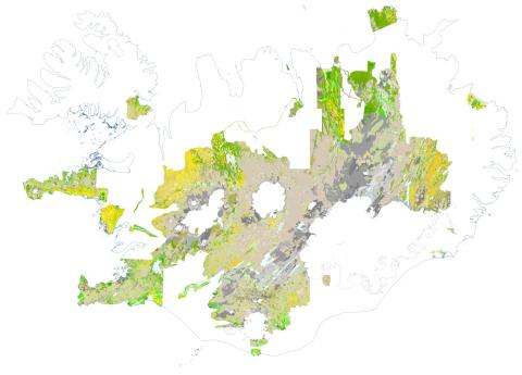
Vegetation map of the Central Highland and mapped Lowlands of Iceland
Work is underway on a comprehensive database of geographical information on vegetation in Iceland at a reference scale of 1:25,000. Using this database, a vegetation map of the Central Highland of Iceland and mapped Lowlands has been published. The map covers around 52,000 km2, approximately 50% of the country. The map is based on vegetation data of varying age collected in the field by the former Icelandic Institute of Natural History and RALA, from the beginning of vegetation mapping in Iceland in 1955 up to the year 2022. Additional vegetation mapping data exist from other areas, but these either require digitization or review.
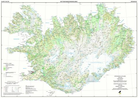
Vegetation map of Iceland, general overview
The former IINH has published a vegetation map of Iceland at a scale of 1:500,000. The map provides a basic overview of dominant vegetation types in Iceland. The map is based on earlier vegetation maps, aerial photographs, satellite images, and a map of birch woods and scrubland produced by the Icelandic Forest Service. The map was published in 1998.
Vegetation and parcel map series (Rala) 1:25,000
A total of 28 vegetation and parcel maps, showing five major vegetation types that are sub-divided into eight vegetation groups. Vegetation types are distinguished by colour. The maps also show land types, farm property boundaries, and county and district boundaries. The maps were published by the Icelandic Agricultural Research Institute (Rala) in the years 1977–1987.
Sheet index (pdf)
Download (tiff, georeferenced)
 1:25.000 - Eldborgarhraun")
Vegetation and parcel map series (Rala) 1:20,000
A total of 11 vegetation and parcel maps at the scale of 1:20,000. They show vegetation and land types, farm property boundaries, and county and district boundaries. Vegetation is classified into 90 different plant sociations. The maps were published by the Icelandic Agricultural Research Institute (Rala) in the years 1968–1977.
Sheet index (pdf)
Download (tiff, georeferenced)
 1:20.000 - Gilsbakki")
Vegetation map of Iceland (Rala) 1:40,000
A total of 65 vegetation maps at the scale of 1:40,000. They show vegetation and land types and rangeland in the highlands of Iceland. Vegetation is classified into 90 different plant sociations. Their purpose was to determine grazing tolerance of rangeland and manage land use for grazing. The maps were published by the Icelandic Agricultural Research Agency (Rala) in the years 1961–1980.
Sheet index (pdf)
Download (tiff, georeferenced)
 1:40.000 - Hvítárvatn")